


Drillhole WMA082-11 Intersected 6.47% U3O8 Over 25.8 Metres; Including 22.78% U3O8 Over 4.0 Metres
Drillhole WMA082-8 Intersected 7.63% U3O8 Over 16.2 Metres; Including 17.31% U3O8 Over 6.1 Metres
Maximum Geochemical Assay Grade of 69.10% U3O8
Saskatoon, Saskatchewan--(Newsfile Corp. - October 10, 2024) - CanAlaska Uranium Ltd. (TSXV: CVV) (OTCQX: CVVUF) (FSE: DH7) ("CanAlaska" or the "Company") is pleased to report that it has received assay results from some of the drillholes completed on the Pike Zone during the summer of 2024. Geochemical assay results confirm high-grade uranium intersections on L85E highlighted by a composited high-grade uranium intersection in WMA082-11 grading 6.47% U3O8 over 25.8 metres, including an ultra high-grade zone of 22.78% U3O8 over 4.0 metres, and WMA082-8 grading 7.63% U3O8 over 16.2 metres, including an ultra high-grade zone of 17.31% U3O8 over 6.1 metres. In addition, geochemical assay results confirm a high-grade composited uranium intersection on L70E in WMA082-7 grading 6.22% U3O8 over 11.4 metres, including 11.40% U3O8 over 5.6 metres.

Figure 1 – West McArthur Project Location
To view an enhanced version of this graphic, please visit:
https://images.newsfilecorp.com/files/2864/226247_832821bb94899aa5_002full.jpg
Drilling at the Pike Zone was completed as part of the 2024 exploration program on the West McArthur Joint Venture project (the "Project") in the eastern Athabasca Basin. The Project, a Joint Venture with Cameco Corporation, is operated by CanAlaska that holds an 83.35% ownership in the Project (Figure 1). CanAlaska is sole-funding the 2024 West McArthur program, further increasing its majority ownership in the Project.
2024 Summer Drill Program

Figure 2 – Pike Zone Plan With Drill Results
To view an enhanced version of this graphic, please visit:
https://images.newsfilecorp.com/files/2864/226247_832821bb94899aa5_003full.jpg
The summer drill program on the West McArthur project consisted of 15 unconformity tests split between Pike Zone expansion and extensional testing along the geophysical corridor. At the Pike Zone, 12 unconformity tests were completed, 11 of which contained uranium mineralization (Figure 2). The results of the summer drill program indicate a strike length of uranium mineralization along the unconformity target area of approximately 200 metres that remains open in all directions. Multiple drill fences within the unconformity target area define a high-grade core that remains open and extends over 100 metres in strike length.
The assay results received from the summer program to date confirm the ultra high-grade radiometric equivalent grades previously reported this summer, with individual assay samples of massive uranium mineralization returning maximum grades up to 69.10% U3O8.
CanAlaska CEO, Cory Belyk, comments, "Assay confirmation of ultra high-grade uranium mineralization at Pike Zone in the first batch of assay samples highlights the ability of CanAlaska's team to generate reasonably accurate radiometric-equivalent grade calculations with our calibrated down-hole probes. Pike Zone is growing rapidly in its footprint and now displays additional areas of ultra high-grade uranium mineralization at the unconformity 100 metres to the west. The mineralization remains open in all directions. With multiple intersections of ultra high-grade uranium now confirmed and with grades as high as 69.10% U3O8, Pike Zone is starting to position itself into a possible world-class uranium discovery located just 12 kilometres from the giant McArthur River uranium mine. The CanAlaska team is now focussed on development of the 2025 drilling plan and budget that will take this discovery to the next level."
The remainder of the geochemical assay results from the summer portion of the 2024 exploration program are pending, with results expected in the next four to six weeks.

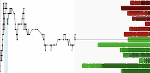
Figure 3 – Pike Zone L70E and L85E Section Assay Results
To view an enhanced version of this graphic, please visit:
https://images.newsfilecorp.com/files/2864/226247_832821bb94899aa5_006full.jpg
2025 Exploration Program and Next Steps
The Company is actively planning the 2025 exploration program on the West McArthur project and is currently engaged in the budget process. It is anticipated that the 2025 exploration program will begin in early January 2025. Details about the program and objectives will be provided once the formal budget has been approved by the Joint Venture.
Drillhole Details:
WMA082-7 was completed along L70E (Figure 3). WMA082-7 intersected one main interval of unconformity-associated uranium mineralization characterized by massive to semi-massive, clay-hosted mineralization associated with yellow and orange uranium secondaries and hematite alteration in the sandstone. Within the unconformity-associated mineralized interval, isolated intervals of core loss were recorded due to intense alteration and quartz dissolution. This was closely followed by an interval of basement-hosted uranium mineralization characterized by nodular, disseminated, clay-hosted, and fracture-controlled veins associated with localized pale-yellow uranium secondaries and strong alteration.
WMA082-8 was completed along L85E (Figure 3). Drillhole WMA082-8 intersected one main interval of basement-hosted uranium mineralization characterized by massive to semi-massive zones of mineralization with foliation- and fracture-controlled mineralization located between the massive zones (Table 2). Additional lower grade intervals of basement-hosted fracture-controlled uranium mineralization were intersected within the graphitic pelite.
WMA082-9 was completed along L85E (Figure 3). Drillhole WMA082-9 intersected one interval of unconformity-associated uranium mineralization within the grey altered sandstone (Table 3). Several intervals of basement-hosted uranium mineralization were intersected throughout the graphitic pelitic rocks (Table 3). These zones are characterized by structurally controlled, disseminated, and foliation-controlled uranium mineralization.
WMA082-11 was completed along L85E (Figure 3). WMA082-11 contains one main interval of unconformity-associated uranium mineralization characterized by massive to semi-massive mineralization associated with strong sooty pyrite, dark red hematite, and intense grey clay replacement alteration immediately around the unconformity contact (Table 4). The lower portion of the unconformity-associated uranium mineralization is structurally controlled, with localized intervals of semi-massive, blebby, and foliation-controlled mineralization within the graphitic pelite rocks. Within the mineralized interval, isolated intervals of core loss were recorded due to intense alteration and quartz dissolution.
Table 1 - WMA082-7 Intersections with Geochemical Assay and Radiometric Equivalent Intervals
| WMA082-7 Intervals 1 | From (m) | To (m) | Length (m)9 | Average Grade | Maximum Grade (% U3O8) | |
| (% U3O8) | (% eU3O8)10 | |||||
| Interval 1 (2) | 795.0 | 796.7 | 1.7 | 0.18 | ||
| | ||||||
| Interval 2 Breakdown (3) | 797.9 | 803.1 | 5.2 | 11.59 | 52.60 | |
| 803.1 | 804.3 | 1.2 | 3.74 | |||
| 804.3 | 806.0 | 1.7 | 0.37 | 0.70 | ||
| 806.0 | 807.1 | 1.1 | 1.37 | |||
| 807.1 | 809.3 | 2.2 | 1.87 | 3.63 | ||
| Composite Interval 2 (3,4) | 797.9 | 809.3 | 11.4 | 6.22 | 52.60 | |
| Including (4,5) | 798.4 | 804.0 | 5.6 | 11.40 | 52.60 | |
| Including (6) | 806.0 | 806.4 | 0.4 | 3.02 | ||
| Including (7) | 807.5 | 809.3 | 1.8 | 2.28 | 3.63 | |
| | ||||||
| Interval 3 (8) | 812.3 | 819.2 | 6.9 | 1.13 | 6.29 | |
| Including (7) | 813.3 | 814.1 | 0.8 | 5.93 | 6.29 | |
| Including (7) | 816.9 | 817.4 | 0.5 | 2.88 | 2.88 | |
| ||||||
Table 2 - WMA082-8 Intersections with Geochemical Assay Intervals
| WMA082-8 Intervals1 | From (m) | To (m) | Length (m)4 | Average Grade (% U3O8) | Maximum Grade (% U3O8) |
| Interval 1 (2) | 822.0 | 822.5 | 0.5 | 0.14 | 0.14 |
| | |||||
| Interval 2 (2) | 823.5 | 839.7 | 16.2 | 7.63 | 69.10 |
| Including (3) | 824.0 | 830.1 | 6.1 | 17.31 | 69.10 |
| Including (3) | 832.0 | 832.8 | 0.8 | 13.09 | 30.80 |
| Including (3) | 838.2 | 839.2 | 1.0 | 4.86 | 6.86 |
| |||||
Table 3 - WMA082-9 Intersections with Geochemical Assay Intervals
| WMA082-9 Intervals1 | From (m) | To (m) | Length (m)4 | Average Grade (% U3O8) | Maximum Grade (% U3O8) |
| Interval 1 (2) | 799.9 | 800.7 | 0.8 | 0.16 | 0.21 |
| | |||||
| Interval 2 (2) | 816.2 | 818.2 | 2.0 | 1.08 | 2.12 |
| Including (3) | 817.2 | 817.7 | 0.5 | 2.12 | 2.12 |
| | |||||
| Interval 3 (2) | 822.7 | 824.2 | 1.5 | 1.23 | 1.23 |
| Including (3) | 823.2 | 823.7 | 0.5 | 2.95 | 2.95 |
| | |||||
| Interval 4 (2) | 826.6 | 827.1 | 0.5 | 0.13 | 0.13 |
| | |||||
| Interval 5 (2) | 845.0 | 846.0 | 1.0 | 0.32 | 0.32 |
| |||||
Table 4 - WMA082-11 Intersections with Geochemical Assay and Radiometric Equivalent Intervals
| WMA082-11 Intervals 1 | From (m) | To (m) | Length (m)6 | Average Grade | Maximum Grade (% U3O8) | |
| (% U3O8) | (% eU3O8)7 | |||||
| Interval 1 Breakdown (2) | 795.9 | 797.0 | 1.1 | 0.63 | ||
| 797.0 | 808.1 | 11.1 | 10.90 | 52.30 | ||
| 808.1 | 809.0 | 0.9 | 2.57 | |||
| 809.0 | 821.7 | 12.7 | 3.39 | 18.20 | ||
| Composite Interval 1 (2,3) | 795.9 | 821.7 | 25.8 | 6.47 | 52.30 | |
| Including (4) | 797.0 | 801.0 | 4.0 | 22.78 | 52.30 | |
| Including (3,5) | 803.0 | 818.4 | 15.4 | 4.36 | 18.40 | |
| Including (4) | 819.9 | 821.2 | 1.3 | 4.78 | 10.20 | |
| ||||||
Other News
The Company will have management representatives at the Red Cloud Fall Mining Showcase on October 16th and 17th in Toronto, Ontario.
The Company invites you to view a special video tour of the West McArthur uranium project. This video provides an exclusive look at our key exploration activities and the exciting potential of the Pike Zone discovery. The video tour is available on the Company's YouTube channel or through the following link: Inside West McArthur: Exploring High-Grade Uranium with CEO Cory Belyk and VP Nathan Bridge (youtube.com).
Geochemical Sampling Procedures and Use of Radiometric Equivalent Grades
All drill core samples from the program were shipped to the Saskatchewan Research Council Geoanalytical Laboratories (SRC) in Saskatoon, Saskatchewan in secure containment for preparation, processing, and multi-element analysis by ICP-MS and ICP-OES using total (HF:NHO3:HClO4) and partial digestion (HNO3:HCl), boron by fusion, and U3O8 wt% assay by ICP-OES using higher grade standards. Assay samples are chosen based on downhole probing radiometric equivalent uranium grades and scintillometer (SPP2 or CT007-M) peaks. Assay sample intervals comprise 0.3 - 0.8 metre continuous half-core split samples over the mineralized intervals. With all assay samples, one half of the split sample is retained and the other sent to the SRC for analysis. The SRC is an ISO/IEC 17025/2005 and Standards Council of Canada certified analytical laboratory. Blanks, standard reference materials, and repeats are inserted into the sample stream at regular intervals by CanAlaska and the SRC in accordance with CanAlaska's quality assurance/quality control (QA/QC) procedures. Geochemical assay data are subject to verification procedures by qualified persons employed by CanAlaska prior to disclosure.
During active exploration programs drillholes are radiometrically logged using calibrated downhole GeoVista NGRS and TGGS (Triple GM) gamma probes which collect continuous readings along the length of the drillhole. Preliminary radiometric equivalent uranium grades ("eU3O8") are then calculated from the downhole radiometric results. The probe is calibrated using an algorithm calculated from the calibration of the probe at the Saskatchewan Research Council facility in Saskatoon and from the comparison of probe results against geochemical analyses. At extremely high radiometric equivalent uranium grades, downhole gamma probes may become saturated, resulting in the probe being overwhelmed, which in turn can create difficulties in accurately determining extremely high-grade radiometric equivalent uranium grades, and a cap may be applied to the grade. The equivalent uranium grades are preliminary and are subsequently reported as definitive assay grades following sampling and chemical analysis of the mineralized drill core. In the case where core recovery within a mineralized intersection is poor or non-existent, radiometric grades are considered to be more representative of the mineralized intersection and may be reported in the place of assay grades. Radiometric equivalent probe results are subject to verification procedures by qualified persons employed by CanAlaska prior to disclosure.
All reported depths and intervals are drill hole depths and intervals, unless otherwise noted, and do not represent true thicknesses, which have yet to be determined.
About CanAlaska Uranium
CanAlaska Uranium Ltd. (TSXV: CVV) (OTCQX: CVVUF) (FSE: DH7) is a Canadian based exploration company and holds interest in approximately 500,000 hectares (1,235,000 acres) in Canada's Athabasca Basin focused on exploration and discovery of high-grade unconformity uranium deposits. The Company is actively advancing the Pike Zone discovery - a new high-grade uranium discovery on its West McArthur Joint Venture project in the eastern Athabasca Basin. In addition, the Company has several other uranium-focused exploration programs. CanAlaska deploys a hybrid project generator model, focusing on the acquisition and sale of prospective projects, while also executing exploration programs on CanAlaska's most strategic land holdings. The Company's extensive portfolio has attracted international mining companies, including Cameco Corporation and Denison Mines as active partners. CanAlaska is led by an experienced team of professionals with a proven track record of discovery.
The Company's head office is in Saskatoon, Saskatchewan, Canada with a satellite office in Vancouver, BC, Canada. For further information visit www.canalaska.com.
The Qualified Person under National Instrument 43-101 Standards of Disclosure for Mineral Projects for this news release is Nathan Bridge, MSc., P. Geo., Vice-President Exploration for CanAlaska Uranium Ltd., who has reviewed and approved its contents.
On behalf of the Board of Directors
"Cory Belyk"
Cory Belyk, P.Geo., FGC
CEO, President and Director
CanAlaska Uranium Ltd.
Contacts:
| Cory Belyk, CEO and President | General Enquiry |
| Tel: +1.306.668.6900 | Tel: +1.306.668.6915 |
| Email: cbelyk@canalaska.com | Email: info@canalaska.com |
Neither TSX Venture Exchange nor its Regulation Services Provider (as that term is defined in the policies of the TSX Venture Exchange) accepts responsibility for the adequacy or accuracy of this release.
Forward-looking information
All statements included in this press release that address activities, events or developments that the Company expects, believes or anticipates will or may occur in the future are forward-looking statements. These forward-looking statements involve numerous assumptions made by the Company based on its experience, perception of historical trends, current conditions, expected future developments and other factors it believes are appropriate in the circumstances. In addition, these statements involve substantial known and unknown risks and uncertainties that contribute to the possibility that the predictions, forecasts, projections and other forward-looking statements will prove inaccurate, certain of which are beyond the Company's control. Readers should not place undue reliance on forward-looking statements. Except as required by law, the Company does not intend to revise or update these forward-looking statements after the date hereof or revise them to reflect the occurrence of future unanticipated events.
![]()
To view the source version of this press release, please visit https://www.newsfilecorp.com/release/226247

